
Page 13 - WINTER2019
P. 13
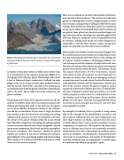
 Figure 2. Photograph of a tidewater glacier. Snowfall in the accumulation zone feeds the glacier that ends with its terminus in the fjord. Photograph by Dale Stokes.
in Alaska) or from more distant ice fields and ice sheets (such as in Greenland or on the Antarctic peninsula). Figure 2 is a photograph of the tidewater glacier Samarinvågen taken from a boat in Hornsund Fjord, southwestern Svalbard (an archi- pelago in the Arctic Ocean situated about midway between Norway and the North Pole). Snowfall in the mountainous accumulation zone feeds the glacier, which flows downhill and ends in the fjord. The ice cliff in the ocean is known as the glacier terminus.
The position and velocity of the glacier terminus are the net result of ice outflow, which drives the terminus onward, with melting and calving that erode it. Net mass loss of a glacier occurs when ablation (melting or calving) at the terminus exceeds the accumulation of new snow at high elevations. Any increase in the twin processes of melting and calving unbalanced by increases in snow accumulation will drive the retreat of the glacier terminus from the ocean toward land. The relative importance of melting and calving to glacial retreat is currently debated and is likely changeable, depend- ing on ocean temperature; local winds and other atmospheric processes; and glacier flow dynamics. Models for glacial stability are sensitive to the roles of melting and calving in glacial ablation. Thus, quantifying models and understanding their responses to warming atmospheric and oceanic condi- tions are active areas of research.
There are no methods for the direct observation of submarine melt rates for tidewater glaciers. The terminus of a tidewater glacier or a floating sheet of ice is a dangerous place to work. This is because calving produces falling ice followed by a mini tsunami, both of which are hazardous, and so it is considered unsafe to get within a few hundred meters of the terminus of any glacier. Some glaciers are known to produce bigger calv- ing events than others, and all glaciers should be approached with care. Moreover, the glacier surface is typically fractured by crevasses, making work on the ice surface dangerous or impossible as well. For these reasons, remote sensing tech- niques are primarily used to study terminus behavior.
Many satellite and airborne remote sensing techniques pro- duce reliable and accurate estimates of average bulk ice mass loss, but measuring the melt rate relative to the calving rate of a glacier terminus remains a challenging problem. Cur- rent techniques include estimates of underwater melt rates based on calculations of heat flux to the glacier or numerical models of circulation within the fjord. Calculations of heat flux require observations of water temperature, salinity, and velocity in front of the glacier on short timescales. In the absence of these data, which are challenging to obtain, assumptions must be made about the distributions of gla- cially modified seawater and the temperature, salinity, and flow of the seawater around the glacier terminus, includ- ing poorly understood turbulent processes. Thermohaline structure is dynamic around a glacier terminus. As a result, tidally pumped seawater interacts with meltwater from the terminus and icebergs and buoyancy-driven, outflow plumes to create space- and time-varying freshwater lenses in the bay in which strength and structure vary over time and geographic location.
For example, in Svalbard, there is typically a strong season- ality to the strength of the thermohaline circulation and also to glacier melting because the ocean temperatures can show large variations. In Alaska, such processes also occur in winter because there is not as much seasonality to ocean temperatures. In Antarctica, the warmth of the ocean water varies in different ways that are not necessarily seasonally linked and can also show a dependence on weather patterns and sea ice conditions. The bottom line is that models of melt rate based on measurements and models of thermohaline structure will likely have to accommodate a variable range of conditions depending on geographic region.
 Winter 2019 | Acoustics Today | 13
