
Page 27 - WINTER2019
P. 27
Tomography Potential on the Comprehensive Nuclear Test Ban Treaty Network
Although it is clear that the accuracy with which we know the climate state of the ocean is needed for triangulation, knowing the ocean climate is of great importance to human civilization. As the oceans of the Earth are the primary heat sink on the planet, thermal expansion of the seawater from increasing temperature is a major factor driving rising sea levels. The methods currently being utilized to determine ocean temperature are based on direct sampling from oceanographic profilers or indirect measurements from space-based sensors. Oceanographic profilers represent point measurements of temperature (and other essential ocean variables) with respect to depth and include moored or ship-based measurements systems and autonomous systems such as sea gliders or drifting Argo floats (see argo.ucsd.edu). These space-based sensors, like those on the Geostationary Operational Environmental Satellites (GOES), provide two important parameters for ocean temperature and climate estimation and sea surface- and depth-averaged ocean tem- perature (as inferred by thermal expansion). In theory, with a dense enough network, this might be sufficient. However, maintaining global coverage with these types of systems requires ongoing deployment operations, and some areas, specifically near the poles, are extremely difficult to sample due to currents and sea-ice coverage.
This deficiency in sampling the ocean climate can be ful- filled with acoustic ocean tomography. Ocean tomography is based on receiving a signal from a source with precisely known origin and inferring temperature. As with the San Juan signal, arrival times depend explicitly on the depth and range dependence of the ocean temperature. Modal arrivals comprising the dispersed signal propagate through different depth regimens (e.g., refer to the polar profile propagation in Figure 6, right) and each provides an additional depth- dependent constraint to estimate the ocean climatic state. Acoustic thermometry (tomography) was proven viable through experiments starting as early as the 1970s (Spindel and Worcester, 2016) and began to be implemented from 1997 to 2006 during the Acoustic Thermometry for Ocean Climate program (Worcester et al., 2005). Now, with the six CTBT hydroacoustic stations online, there is a “cost-free” (expense absorbed by its primary mission) set of receivers and data repositories with which to implement these studies.
Summary
The CTBT hydroacoustic stations proved invaluable to the discovery of the San Juan submarine. Figure 9 shows the map of the data used to plan the search (red star is “the ‘as found’ position, only 8 nm [15 km] from the US and CTBTO centroids”; Ocean Infinity, personal communication, 2019). This amazing feat, pinpointing the location of a source to
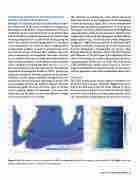
Figure 8. Left: three mode-1 arrivals to triangulate the ARA San Juan (star), plotted over a map of its phase speed at 10 Hz. Right: intersection of the corresponding “isochrons” plotted over the bathymetry.
Winter 2019 | Acoustics Today | 27
