
Page 56 - Spring2020
P. 56
Arctic Acoustic Oceanography
salinity, and other variables cannot surface in ice-covered regions to use the Global Navigation Satellite System (GNSS) to determine their position and to relay data back to shore, for example. Furthermore, measurements of sea sur- face height using satellite altimeters, which provide important constraints on the ocean circulation at lower latitudes, are not feasible when the ocean is covered with ice. Multipurpose acoustic systems can operate beneath the ice, however. Such systems provide acoustic remote sensing of ocean tempera- tures (ocean acoustic tomography), underwater navigation, and passive acoustic monitoring of natural and anthropo- genic sounds. Thus, such systems have a special role to play in making measurements of the rapidly changing Arctic Ocean, complementing and supporting other in situ observations (Mikhalevsky et al., 2015; Howe et al., 2019).
At the same time, even as sound is used to help monitor the changes in the Arctic, the changes in the ice cover and stratifi- cation have affected acoustic propagation and ambient sound.
As a consequence, what was learned about Arctic acoustics during the Cold War is now largely obsolete.
In this article, we describe a series of experiments that have been performed both to determine the effect of the changes in the Arctic on the acoustics and to use acoustic remote sensing as a tool to study the changing Arctic environment. The dis- cussion of the experiments is preceded by a brief description of the extraordinary changes currently occurring in the Arctic and some background on Arctic acoustics. Multipurpose Acoustic Systems in the Arctic Ocean Observing System
Figure 2. Average monthly September sea ice extent from 1979 to 2019. The straight line is a linear fit showing a decline of 12.9% per decade. From the National Snow and Ice Data Center, 2019
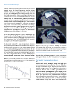
Figure 3. Arctic sea ice age in September 1984 (top) and September 2019 (bottom). Dark blue, younger sea ice, or first-year ice; white, ice that is four years old or older. From the National Aeronautics and Space Administration (NASA) Scientific Visualization Studio, 2019.
describes how multipurpose acoustic systems complement and support other in situ observations in ice-covered regions.
The Rapidly Changing Arctic Ocean
Ice
Satellites with passive microwave sensors have made accu- rate measurements of the areal extent of sea ice (defined as the area of ocean with at least 15% sea ice) since 1979. The monthly average extent of ice in September, when it is at a minimum, declined from 7.5 million square kilometers in 1980 to 4.4 million square kilometers in 2019 (Figure 2). The minimum extent in the satellite record occurred on Septem- ber 16, 2012, when there were 3.4 million square kilometers of ice. Although there is considerable year-to-year variability, a linear fit yields a decline of 12.9% per decade in the Sep- tember monthly average from 1979 to 2019 (National Snow
56 | Acoustics Today | Spring 2020
