
Page 53 - Winter 2020
P. 53
operations, freeing them up for other tasks as well as reducing human errors.
Overview and History of the Global Positioning System
The GPS is owned by the US Government and is operated and maintained by the US Air Force out of Shriever Air
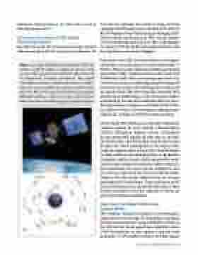
Force Base in Colorado. The system is young, relatively speaking. The GPS project was started in 1973, and the first NAVigation System with Timing and Ranging (NAV- STAR) satellite was launched in 1978. The 24-satellite system became fully operational in 1995. A photograph of a modern GPS-III satellite and a depiction of the satel- lite constellation are shown in Figure 1.
A precursor to the GPS, the Transit System, was designed specifically to provide accurate location information to US Navy Polaris nuclear submarines and became the first operational satellite navigation system in 1964 (Guier and Weiffenbach, 1998). There is not enough space here to go into all of the science and technology advances that paved the way for the modern GPS, including the satellite geod- esy work of Gladys Mae West (featured in Shetterly, 2016, and the movie Hidden Figures), but the gps.gov website, maintained by the national coordination office for space- based positioning, navigation, and timing and hosted by the National Oceanic and Atmospheric Administration (NOAA) has a wealth of useful information and links.
The US-based GPS satellites are not the only navigational satellites orbiting the earth. Indeed, a Russian-based GLObal NAVigation Satellite System (GLONASS) became operational around the same time as the GPS. The United States and Russia both started construction of their own GNSS constellations at the height of the Cold War. More recently, in June 2020, China launched the final satellite in the third generation of the BeiDou Navigation Satellite System, which now provides world- wide coverage. Europe has launched Galileo, which has been operational since 2019, and the complete 30-satel- lite system is expected by the time you read this article. Galileo is the only purely civilian system; the systems launched by the United States, China, and Russia are all at least partially owned or operated by the military. Most modern smartphones have the capability to receive sig- nals from multiple constellations.
How Does the Global Positioning
System Work?
GPS satellites continuously broadcast electromagnetic signals that travel through the atmosphere, providing their location and precise timing information. (I refer to the GPS, but this can be applied more globally to other GNSS constellations as they operate using the same principles.) A GPS satellite transmits multiple signals,
Figure 1. a: Image of Global Positioning System (GPS) III satellite. A GPS III satellite is roughly the size of a small car and orbits approximately 20,200 km above the earth. b: Configuration of satellite constellation. The original constellation contained 6 orbitals with slots for 4 satellites each, and only 24 satellites are required to operate at any given time. But, in 2011, this was expanded to accommodate additional satellites to improve coverage. Source: United States Government (available at gps.gov/multimedia/images).
Spring 2021 • Acoustics Today 53
