
Page 54 - Winter 2020
P. 54
UNDERWATER GPS
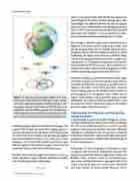
Figure 2. a: Depiction of positioning of a GPS receiver using trilateration in three dimensions. Each sphere with a satellite at its center represents the distance calculated from Eq. 1. The four spheres intersect at the location of the GPS receiver. b: Trilateration with four satellites projected onto two dimensions with the single point of intersection determining the location of the GPS receiver. Presented with permission from gisgeography.com.
including ranging signals and navigation messages. The original GPS design contained two ranging signals: a coarse/acquisition (C/A) code and a restricted precision (P) code reserved for military and government applica- tions. Each satellite transmits a C/A code with a carrier frequency of 1,575.42 MHz. Galileo and BeiDou also transmit signals at this carrier frequency, which is in the microwave band, outside of the visible spectrum.
The time that it takes the signal to reach the receiver is used to calculate a range or distance (d) from the satellite with the following simple relationship
d = c × t 1) 54 Acoustics Today • Spring 2021
where c is the speed of light (299,792,458 m/s) and t is the time of flight for the signal traveling through space. This time of flight is the difference between the time the signal is broadcast by the satellite and the time the signal is received. Once a GPS receiver obtains the distance between itself and at least four satellites, it can use geometry to deter- mine its location and simultaneously correct its time.
The concept is relatively simple and is demonstrated in Figure 2. If we know just the range from a single satel- lite, the location of the receiver could be anywhere on an imaginary sphere with the satellite located at its center. Combining the ranges received from 4 satellites, along with precise timing information, provides a single inter- section point in 3-dimensional space that corresponds to the position of the GPS receiver. This is referred to as trilateration (often confused with triangulation, which involves measuring angles rather than distances).
Apparent from Eq. 1, an inaccurate estimate of the signal travel time will give an incorrect distance from receiver to satellite and therefore an inaccurate position. Precise timing is therefore vital to GPS operation. Nanosec- onds in timing error on the satellites lead to meters of positioning error on the ground. Each satellite has an atomic clock onboard, which provides precise timing information. These precise clocks are updated twice a day to correct the clock’s natural drift using an even higher precision atomic clock based on land.
Underwater Positioning and Navigation Using Acoustics
It is interesting to note that satellite navigation systems were first designed with submarines in mind even though the GPS is not useful beneath the sea surface. Electro- magnetic waves from the satellites travel very efficiently through the atmosphere but are quickly attenuated underwater. Underwater vehicles and underwater instru- mentation are therefore unable to take full advantage of the GPS infrastructure.
Submarines do take advantage of underwater acous- tic signals, and the field of underwater acoustics has largely been driven by military applications (Muir and Bradley, 2016). Acoustic waves are mechanical pres- sure waves and therefore do not propagate well in the (near) vacuum of space but travel more efficiently and more quickly in denser media. Because of this,
