
Page 58 - Winter 2020
P. 58
UNDERWATER GPS
positioning algorithms. The sources used in this particu- lar experiment had a center frequency of about 250 Hz and a bandwidth of 100 Hz.
The sources were used to localize autonomous underwater vehicles that had access to a GPS at the sea surface but only surfaced a few times a day. Hydrophones on the vehicles received acoustic transmissions from the moored sources at ranges up to 700 km, and these signals were used to esti- mate the position of the vehicle when it was underwater (Van Uffelen et al., 2013). The measured acoustic arrivals were similar to the modeled arrival shown in Figure 4d. The measurements of these peaks collected on the vehicle were matched to predicted ray arrivals to determine range. This method takes advantage of the multipath arrivals in addition to signal travel time. As with other acoustic methods and with the GPS, ranges from multiple sources were combined to obtain estimates of vehicle position. The resulting positions had estimated uncertainties less than 100 m root mean square (Van Uffelen et al., 2015).
Other long-range acoustic-ranging methods incorporate pre- dictions of acoustic arrivals based on ocean state estimates (Wu et al., 2019). An algorithm introduced by Mikhalevsky et al. (2020) provides a “cold start’ capability that does not require an initial estimate of the acoustic arrival and has positioning orders on the order of 60 m. These results were validated using hydrophone data with known positions that received the Philippine Sea source signals. As with the afore- mentioned method, this algorithm relies on the travel-time resolution afforded by the broadband source signals.
How Feasible Is a Global Navigation Acoustic System?
Because acoustic signals are able to propagate over extremely
long ranges underwater, acoustics could provide an under- water analogue to the electromagnetic GNSS signals that are used for positioning in the land, air, and space domains. There are definite differences between using an underwater acoustic positioning system and a GNSS, however. GNSS satellites orbit the earth twice a day and transmit continu- ously. Acoustic sources do not need to be in orbit, but proper placement of the sources would enable propagation to most regions in the oceans of the world.
The far reach of underwater acoustic propagation is dem- onstrated by the International Monitoring System (IMS) operated by the Comprehensive Nuclear Test Ban Treaty Organization (CTBTO). The IMS monitors the globe for acoustic signatures of nuclear tests with only six under- water passive acoustic hydrophone monitoring stations worldwide. Figure 5 shows the coverage of these few sta- tions. Signals received on these hydroacoustic stations were used to localize an Argentinian submarine that was lost in 2017 using acoustic recordings of the explosion on IMS listening stations at ranges of 6,000 and 8,000 km from the site (Dall’Osto, 2019).
You may note that Figure 5 does not show much coverage in the Arctic Ocean and that the sound speed structure is quite different at high latitudes because it does not have the warm surface that we see in Figure 3; however, long- range propagation has been demonstrated in the Arctic
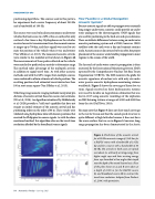
Figure 4. Predictions of the acoustic arrival for a 260-Hz source at a range of 1,145 km. for a RAFOS source with a bandwidth of 1.6 Hz (a) and for a source with a bandwidth of 50 Hz (b). The arrivals in both cases are spread over about 4 s, with early arriving energy from higher angle rays and later arriving energy from rays launched at low angles that stayed near the depth of the sound channel axis. Slices of the plots shown in a and b were taken at a depth of 2,000 m for the RAFOS source (c) and broadband source (d) to contrast the travel time resolution. Adapted from Duda et al., 2006, with permission.
58 Acoustics Today • Spring 2021
