
Page 59 - Spring2020
P. 59
sources of sound. The level and character of ambient sound in the Arctic can be expected to change as the ice coverage and thickness decrease and anthropogenic activities, such as seismic exploration, fishing, and shipping, increase. Ambi- ent sound in the Arctic is highly variable in space and time, however, and no trends are yet evident (Ozanich et al., 2017).
Arctic Ocean Acoustic Tomography
Ocean acoustic tomography is a method for remote sensing of the ocean interior by transmitting sound through it (Munk et al., 1995; Worcester et al., 2005). The speed at which sound travels through the ocean depends on the temperature and velocity fields, and precise measurements of acoustic travel times therefore provide information on ocean temperature and current. Inverse methods are used to infer the state of the ocean traversed by the signals from the measured travel times. The effects of ocean currents on travel times are typi- cally one to two orders of magnitude less than the effects of sound speed perturbations, but they can still be measured by transmitting sound in opposite directions (reciprocal trans- missions). Sound traveling with a current travels faster than sound traveling against it.
Travel times are inherently spatially integrating, providing hori- zontal and vertical averages over long ranges and suppressing the effects of small-scale oceanic variability that can contaminate point measurements. The application of long-range transmis- sions to measure ocean temperature is often referred to as
“acoustic thermometry,” usually in the context of geometries for which there are few or no crossing acoustic paths.
Basin Scales
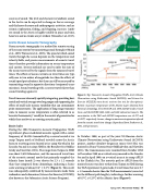
During the 1994 Transarctic Acoustic Propagation (TAP) experiment, phase-modulated acoustic signals with a center frequency of 19.6 Hz transmitted by a source located at ice camp Turpan north of Svalbard traveled across the Arctic basin to receiving arrays located at ice camp Narwhal in the Lincoln Sea and ice camp SIMI in the Beaufort Sea (Mikha- levsky and Gavrilov, 2001). The range from Turpan to SIMI was about 2,630 kilometers, and the measured travel time of the acoustic normal mode that primarily sampled the Atlantic layer (mode 2) was shorter by 2.3 ± 1.2 seconds than that computed from climatology, indicating a basin- scale warming of almost 0.4° ± 0.2°C (Figure 6). This result was subsequently confirmed by measurements made from icebreakers and submarines (Science Ice Exercise [SCICEX]; also known as the Submarine Arctic Science Program).
Figure 6. Top: Transarctic Acoustic Propagation (TAP), Arctic Climate Observations using Underwater Sound (ACOUS), and Science Ice Exercise (SCICEX) trans-Arctic sections (see text for descriptions). Bottom: maximum temperatures of the Atlantic Layer obtained from historical climatology, the 1994 TAP and 1999 ACOUS mode-2 travel times, and the SCICEX 1995, 1998, and 1999 submarine transects. The uncertainties in the TAP and ACOUS temperatures are ±0.2°C and ±0.25°C, respectively. Arrows, change in maximum temperature inferred from the acoustic travel time changes. Reproduced from Dushaw et al., 2001, with permission.
In October 1998, as part of the joint US-Russian Arctic Climate Observations using Underwater Sound (ACOUS) project, another ultralow-frequency source (20.5 Hz) was moored in Franz Victoria Strait (Mikhalevsky and Gavrilov, 2001). The transmissions were recorded from October 1998 to December 1999 on a vertical array moored in the Lincoln Sea and in April 1999, on a vertical array at ice camp APLIS in the Chukchi Sea. The acoustic path to APLIS from the moored source was close to that from Turpan to SIMI during the TAP experiment. It gave mode-2 travel times that were 2.7 ± 1.3 seconds shorter than the TAP measurements (corrected for the different path lengths), indicating a further warming of 0.5°C ± 0.25°C of the Atlantic layer (Figure 6).
Spring 2020 | Acoustics Today | 59
