
Page 61 - Spring2020
P. 61
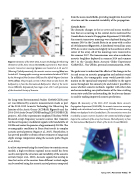
 Figure 9. Geometry of the 2010–2012 Acoustic Technology for Observing the Interior of the Arctic Ocean (ACOBAR) experiment in Fram Strait. Acoustic transceiver moorings (green) were located at A, B, and C. (Mooring C failed prematurely.) An acoustic receiver mooring (blue) was located at D. Oceanographic moorings were maintained at about 78°50'N by the Norwegian Polar Institute (NPI) and the Alfred Wegener Institute (AWI; yellow). The principal currents in Fram Strait are also shown. The bathymetry is from the International Bathymetric Chart of the Arctic Ocean (IBCAO). Reproduced from Sagen et al., 2017, with permission of the Acoustical Society of America.
for Long-term Environmental Studies (DAMOCLES) proj- ect was followed by acoustic measurements made as part of the 2010–2012 Acoustic Technology for Observing the Interior of the Arctic Ocean (ACOBAR; Figure 9) and the 2014–2016 Arctic Ocean UNDER melting ICE (UNDER-ICE) projects. All of the experiments employed Teledyne Webb Research swept-frequency acoustic sources that transmit- ted linear frequency-modulated signals with bandwidths of 100 Hz and center frequencies of approximately 250 Hz. The oceanographic conditions in Fram Strait result in complex acoustic arrival patterns (Sagen et al., 2017). Nonetheless, it has proved possible to obtain robust estimates of range and depth average temperature along the acoustic paths (Sagen et al., 2016).
As a first step toward using the travel times to constrain ocean models, a high-resolution regional ocean model has been used to interpret the structure and variability of the acoustic arrivals (Geyer et al., 2020). Acoustic signals that overlap in time but arrive at the receiver from different vertical angles can be resolved using the acoustic arrival patterns computed
from the ocean model fields, providing insight into the arrival structure and the seasonable variability of the propagation.
Canada Basin
The dramatic changes in the ice cover and ocean stratifica- tion that are occurring in the central Arctic motivated the Canada Basin Acoustic Propagation Experiment (CANAPE). Six acoustic transceiver moorings were deployed during late summer 2016 in the Canada Basin in an array with a radius of 150 kilometers (Figure 10). A distributed vertical line array (DVLA) receiver was located slightly to the northwest of the center of the array. All of the moorings were recovered in late summer 2017. The transmissions were also recorded on acoustic Seagliders deployed in summer 2016 and summer 2017 in the Canada Basin Acoustic Glider Experiment (CABAGE; L. Van Uffelen, personal communication, 2019).
The goals were to understand the effects of the changes in the ice and ocean on acoustic propagation and ambient sound. In addition, the tomographic array would provide infor- mation on the spatial and temporal variability in the upper ocean throughout the annual cycle and make it possible to assess whether acoustic methods, together with other data and ocean modeling, can yield estimates of the time-evolving ocean state useful for understanding the local ocean dynam- ics and for making improved acoustic predictions.
Figure 10. Geometry of the 2016–2017 Canada Basin Acoustic Propagation Experiment (CANAPE). Six acoustic transceiver moorings (white) and a distributed vertical line array (DVLA) receiver mooring (blue) were deployed in the Canada Basin. The transmissions were also recorded by acoustic receivers located on the continental shelf and upper slope to the southwest of the array (not shown). The bathymetry is from the International Bathymetric Chart of the Arctic Ocean (IBCAO).
  Spring 2020 | Acoustics Today | 61
